Delica to the top of a mountain bike race

4x4 trips to Mexico, to the ski hill, or to the local grocery store...

Moderator: mark

Post Reply
User avatar
Erebus
Posts: 1369
Joined: Mon May 28, 2007 7:55 pm
Member's Photo Album: http://www.delica.ca/Photos/
Vehicle: 1992 Super Exceed
Location: Edmonton, Alberta
Location: Edmonton (was Calgary until 2017), Alberta, Canada
Contact:

Delica to the top of a mountain bike race

Post by Erebus »

[Part 1 of 3]
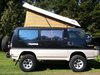
Once again, the Delica proves its versatility.

The Bow-80 is a mountain bike race held (almost) every year west of Calgary in September. This year's race took place Sunday 20 September, circling Moose Mountain for a total distance of 80 kilometres. This race is for the hardcore types, not the faint of heart. Go to http://www.bow80.com for the race stuff.
Moose Mtn map.jpg
Moose Mtn map.jpg (144.17 KiB) Viewed 5322 times
The blue line is the course. Start/finish is to the bottom right, the race runs clockwise, Checkpoint 19 is in the upper left, and my position is indicated by the black circles in the centre.

Anyway ... The problem with having a mountain in the middle of the course is that communications get complicated. So, the race usually has a ham radio operator stationed on the top of the mountain, using a combination of ham, commercial and forestry radios. Great fun when 3 stations call you at the same time on 3 different radios. The last two years, that net control person has been me.

There is a 6 km 4x4 trail that takes you from the upper parking lot to the east summit. It requires permission from the authorities to get through the gate at the parking lot. This year, we were able to get permission for me to go up the afternoon before and spend the night, rather than having to drive up in the morning. Given that the radio net starts at 0700, it requires an early start, and little room for delays like flat tires.

So, anyway, Saturday afternoon I headed up, with Brennan in his Jeep Cherokee escorting me as safety (and as an excuse to go up the mountain), but he would be turning around and going back down again as soon as I got to the top. A kilometre or two onto the trail, I stopped to photograph the peak. The red arrow points to the east summit, where I'd be spending the next 24 hours. Another bit in, I stopped to chat with a couple of older ladies heading down. One asked if I would be willing to give her a ride on the way down. When I said, "sure, but I'm not coming back down until tomorrow night," she looked a tad shocked.
1 Looking to summit420.jpg
1 Looking to summit420.jpg (46.9 KiB) Viewed 5299 times
A couple of kilometres further, still on a pretty easy trail, we stop at a nice open area, and I take a shot to give you an idea of what the trail looks like.
2 Easy trail 425.jpg
2 Easy trail 425.jpg (135.35 KiB) Viewed 5301 times
From that location, I took another shot of the mountain, showing the switchbacks that go to the east summit. In 2008 there was too much snow, so I couldn't make it to the top in the time I had, so I spent the day on one of the switchbacks. But this year, it was 25 degrees and windy, with a forecast low of 8 Celcius and overcast and a high of 14 for Sunday.
3 Summit from clearing 424.jpg
3 Summit from clearing 424.jpg (56.93 KiB) Viewed 5295 times
So the drive up should be no problem.

Part way up one switchback, I stopped to photograph Brennan on a previous leg. This gives you an idea of what kind of view I would be getting. We're almost at the top. Once there, Brennan headed back down to continue with his organizer duties.
4 On the switchbacks 433.jpg
4 On the switchbacks 433.jpg (64.79 KiB) Viewed 5290 times
After he left, the fire lookout guy came down, we talked and then we hiked up to the lookout. It took about 25 minutes to hike the couple of hundred metres that includes an elevation gain of about 100 metres (300 feet). This shot shows the lookout, taken from just before you get there.
8 Lookout from trail 460.jpg
8 Lookout from trail 460.jpg (72.6 KiB) Viewed 5285 times
.
Yes, it really is that steep. Note that there is no bare bedrock, everything is covered in chunks of sharp, jagged, frost-shattered carbonate rocks.
Last edited by Erebus on Sun Sep 27, 2009 8:27 am, edited 2 times in total.
Image "I could be just around the corner from heaven, or a mile from hell." -- Jackson Browne, "The road and the sky".
User avatar
Erebus
Posts: 1369
Joined: Mon May 28, 2007 7:55 pm
Member's Photo Album: http://www.delica.ca/Photos/
Vehicle: 1992 Super Exceed
Location: Edmonton, Alberta
Location: Edmonton (was Calgary until 2017), Alberta, Canada
Contact:

Re: Delica to the top of a mountain bike race

Post by Erebus »

[Part 2 of 3]
5 Lookout from helipad 443.jpg
5 Lookout from helipad 443.jpg (73.14 KiB) Viewed 5263 times
This shot is taken from the helipad. Just to the left of the lookout itself is the radio "cabinet". A sealed steel container with solar panels on two sides, it contains several radio systems used by various govenment agencies. Some antennas are mounted on the cabinet, others are on the mast beside the lookout. Dave, the lookout guy, spends 5 months straight up here every year, the entire fire season, not coming down at all during his tour. Supplies are brought up by helicopter, but many hikers visit. The lookout itself, a 14-foot-by-14-foot single room with windows on all sides, is his office, kitchen and bedroom, all in one! It takes a special kind of person to do that job.
6 Radio shack 444.jpg
6 Radio shack 444.jpg (68.42 KiB) Viewed 5260 times
From the wraparound porch of the lookout, I could look eastward to where the Delica was parked. The red arrow is where the Deli is. On the horizon, just to the right of the Delica, is the city of Calgary, about 55 km away.
7 Deli from lookout 454.jpg
7 Deli from lookout 454.jpg (60.76 KiB) Viewed 5258 times
Leaving Dave to make his dinner, I hiked back down to the Delica, where I prepared for the night. First I had to photograph the altimeter. I challenge anyone to get a higher altitude reading. My GPS reported my altitude as 2341 metres (7682'), which agrees with the map. The lookout is at 2437m (7995'). To give you some scale, the highest point on the Trans-Canada Highway is the Kicking Horse Pass, at only 1643 metres or 700m (2290 feet) lower.
9 Altimeter 2341m 465.jpg
9 Altimeter 2341m 465.jpg (45.26 KiB) Viewed 5263 times
10 Sleeping setup 472.jpg
10 Sleeping setup 472.jpg (60.99 KiB) Viewed 5249 times
You know you have an amazing view when you deliberately keep the curtains open so you can see the view. I fell sleep to the lights of Calgary in the distance, and stars through the Crystal Lite roof. I woke up at about 0430 to discover I couldn't see any lights. I looked out the window at the igloo-like rock structure that was only 10 m away. I couldn't see it! It was lost in the cloud/fog. Even the flashlight didn't penetrate that far. And it had started snowing. I fell asleep again with the Deli rocking in the wind.
Last edited by Erebus on Tue Sep 22, 2009 6:04 pm, edited 1 time in total.
Image "I could be just around the corner from heaven, or a mile from hell." -- Jackson Browne, "The road and the sky".
User avatar
Erebus
Posts: 1369
Joined: Mon May 28, 2007 7:55 pm
Member's Photo Album: http://www.delica.ca/Photos/
Vehicle: 1992 Super Exceed
Location: Edmonton, Alberta
Location: Edmonton (was Calgary until 2017), Alberta, Canada
Contact:

Re: Delica to the top of a mountain bike race

Post by Erebus »

[Part 3 of 3]
When the alarm went off at 0630 I discovered a grey and white world. The forecast had been a little off. Besides not mentioning snow, it was also -3, not +8.
11 Morning wakeup 474.jpg
11 Morning wakeup 474.jpg (49.06 KiB) Viewed 5238 times
After a quick breakfast, and running the engine to warm up the interior, I was on the air just after 0700. Every hour or so I would brave the 60 km/h winds to climb on the roofrack and knock the 1/4 inch ice buildup off the antennas. Not fun, but necessary.

The weather down below on the trails wasn't much better, so shortly before noon, the race organizers decided to cut short the race, and stop all riders at checkpoint 19, about 1/2 around the course. The first 46 riders, who had already passed there, continued, about 100 riders stopped at 19, and about 20 dropped out earlier, many of them quite hypothermic.

After noon, visibility improved, and I could see the lookout.
12 Lookout first look 476.jpg
12 Lookout first look 476.jpg (44.21 KiB) Viewed 5229 times
Then by 1300 it was clear skies, although the temperature had only gotten up to +3. I took a photo up through the Crystal Lite, to show the ice buildup on the roof rack and one of my antennas. The ice built up about 5 cm horizontally, giving a good indication of the wind direction.
13 Roof rack 481.jpg
13 Roof rack 481.jpg (58.97 KiB) Viewed 5231 times
By 1600 much of the snow had melted, except where the Delica had acted as a windbreak and piled up the snow to windward.
14 After clearing 489.jpg
14 After clearing 489.jpg (75.38 KiB) Viewed 5228 times
Shortly thereafter, with all riders safe and sound, and all the shivering volunteers having hiked out from their checkpoints, I shut down the radio net and headed back down the mountain. After a quick meeting at the start/finish line to return the commercial radios I was also using, I headed back home to relax.

Just another day in the life of one Delica.
Image "I could be just around the corner from heaven, or a mile from hell." -- Jackson Browne, "The road and the sky".
User avatar
Kei King
Posts: 125
Joined: Sun Mar 22, 2009 1:58 am
Member's Photo Album: http://www.delica.ca/Photos/
Contact:

Re: Delica to the top of a mountain bike race

Post by Kei King »

Nice post, thanks!
USER BANNED FROM FORUM
User avatar
BCDelica
Posts: 1808
Joined: Tue Jul 18, 2006 4:12 pm
Member's Photo Album: http://www.delica.ca/Photos/index.php?cat=10008
Vehicle: WVO Powered Tuk Tuk
Location: Central Van Isle
Location: Somewhere with plenty of sun

Re: Delica to the top of a mountain bike race

Post by BCDelica »

Great report, thank you. Came close to the top of Moose mountain one day, roughly the same time of year (just after summer) in 1990, but turned back due to a sprained ankle in our small group.

Huge contrast to the highest point in Thailand where it is very lush with vegetation; the number if plants growing on each large tree is staggering. We visited this Sunday as it a beautiful drive and a great way to cool down, temperature at the summit was 14c.

Didn't have a Delica to take the trip but that's 2565 meters elevation.

Image

Best Regards,
Kevin
Image Call me BCDelica-less
User avatar
Spearo
Posts: 279
Joined: Mon Jun 08, 2009 3:03 pm
Member's Photo Album: http://www.delica.ca/Photos/
Vehicle: 92 Smellica Exceed
Location: Edmonton
Location: Edmonton

Re: Delica to the top of a mountain bike race

Post by Spearo »

Really nice adventure report, thanks for the great pics. Gotta love the mountains- especially attempts at weather prediction haha.
"I tell you, we are here on earth to fart around, and don't let anybody tell you different" - Kurt Vonnegut
User avatar
jwfchase
Posts: 508
Joined: Mon Dec 03, 2007 10:36 pm
Member's Photo Album: http://www.delica.ca/Photos/
Vehicle: '92 Super Exceed
Location: Kamloops, BC

Re: Delica to the top of a mountain bike race

Post by jwfchase »

Awesome!
User avatar
after oil
Posts: 1436
Joined: Mon Feb 11, 2008 7:01 pm
Member's Photo Album: http://www.delica.ca/Photos/
Vehicle: 92 cham-reimo poptop L300. 78MB240D
Location: on the road
Location: occupied coast salish territory aka powell river

Re: Delica to the top of a mountain bike race

Post by after oil »

:M :M :M :M
User avatar
mararmeisto
Posts: 3276
Joined: Wed Sep 19, 2007 10:00 am
Vehicle: 2018 Ram EcoDiesel
Location: Dartmouth, NS

Re: Delica to the top of a mountain bike race

Post by mararmeisto »

Nice drive and a spectacular view from the top.

And you're right, the Trans-Canada only gets up to 1643m, but the Kootenay Pass on the #3 is 1770m (did that summer-08).
JPL
I still miss my '94 Pajero!
User avatar
marsgal42
Posts: 772
Joined: Fri Jul 20, 2007 3:05 pm
Member's Photo Album: http://www.delica.ca/Photos/
Vehicle: The Mighty Gumdrop
Location: Burnaby, B.C.

Re: Delica to the top of a mountain bike race

Post by marsgal42 »

I've read claims that Kootenay Pass (1774 meters) is the highest elevation paved road in the country. Pennask Summit (1728 meters) on 97C isn't far behind. Gumdrop has transported me over both.

I've been on tours to the summit of Irazu and Poas Volcanoes in Costa Rica. Both have paved roads to their summits, Irazu is 3432 meters, Poas is "only" 2708 meters. You can sure tell when you (gasp!) get off the (gasp!) bus (gasp!).

...laura
User avatar
Erebus
Posts: 1369
Joined: Mon May 28, 2007 7:55 pm
Member's Photo Album: http://www.delica.ca/Photos/
Vehicle: 1992 Super Exceed
Location: Edmonton, Alberta
Location: Edmonton (was Calgary until 2017), Alberta, Canada
Contact:

Re: Delica to the top of a mountain bike race

Post by Erebus »

Well, Kootenay's claim to be the highest is easily refuted:
DSC02245b.jpg
DSC02245b.jpg (56.41 KiB) Viewed 4911 times
This is the Highwood Pass on highway 40 in Kananaskis Country (just east of Banff Park, south of the Trans-Canada). And this point is higher than the highest point in all other provinces except BC. All three territories do have higher points though.

There are lots of places around the world that have higher passes than here in Canada. I'd love to drive some of them someday. (And some I don't, see http://www.oddee.com/item_96660.aspx) Mount Washington in New Hampshire -- oh, it's only 1917m high -- is a road I'd love to do. The peak of Mt Washington has the highest recorded surface windspeed on the planet: 372 km/h. Check wikipedia for some fun facts about the place -- such as the buildings' walls are chained to the ground. But I digress.
Image "I could be just around the corner from heaven, or a mile from hell." -- Jackson Browne, "The road and the sky".
User avatar
mararmeisto
Posts: 3276
Joined: Wed Sep 19, 2007 10:00 am
Vehicle: 2018 Ram EcoDiesel
Location: Dartmouth, NS

Re: Delica to the top of a mountain bike race

Post by mararmeisto »

marsgal42 wrote:I've read claims that Kootenay Pass (1774 meters) is the highest elevation paved road in the country. Pennask Summit (1728 meters) on 97C isn't far behind. Gumdrop has transported me over both.

I've been on tours to the summit of Irazu and Poas Volcanoes in Costa Rica. Both have paved roads to their summits, Irazu is 3432 meters, Poas is "only" 2708 meters. You can sure tell when you (gasp!) get off the (gasp!) bus (gasp!).

...laura
Kootenay Pass' claim to the highest hinges on the following caveat: The Kootenay Pass is the highest highway-served pass in Canada that is open year-round, although it frequently closes in bad weather. (from Wikipedia)
JPL
I still miss my '94 Pajero!
User avatar
Firesong
Posts: 1363
Joined: Tue Feb 03, 2009 9:03 am
Member's Photo Album: http://www.delica.ca/Photos/
Vehicle: 1998 L400 Delica Chamonix
Location: Saskatoon
Location: Saskatoon, SK. Canada

Re: Delica to the top of a mountain bike race

Post by Firesong »

Excellent adventure thanks for sharing!!
James
User avatar
marsgal42
Posts: 772
Joined: Fri Jul 20, 2007 3:05 pm
Member's Photo Album: http://www.delica.ca/Photos/
Vehicle: The Mighty Gumdrop
Location: Burnaby, B.C.

Re: Delica to the top of a mountain bike race

Post by marsgal42 »

mararmeisto wrote:Kootenay Pass' claim to the highest hinges on the following caveat: The Kootenay Pass is the highest highway-served pass in Canada that is open year-round, although it frequently closes in bad weather. (from Wikipedia)
That's what I get for listening to tourist people. :-D

My trip to Prince Rupert a few weeks ago didn't result in much pass activity. While the Coast Mountains are very high, Highway 16 follows river valleys (Nechako, Bulkley, Skeena) pretty well all the way from Prince George to the coast.

Top Gear were impressed with Stelvio Pass, but some of those other roads look genuinely scary. :shock:

...laura
User avatar
Erebus
Posts: 1369
Joined: Mon May 28, 2007 7:55 pm
Member's Photo Album: http://www.delica.ca/Photos/
Vehicle: 1992 Super Exceed
Location: Edmonton, Alberta
Location: Edmonton (was Calgary until 2017), Alberta, Canada
Contact:

Re: Delica to the top of a mountain bike race

Post by Erebus »

mararmeisto wrote:Kootenay Pass' claim to the highest hinges on the following caveat: The Kootenay Pass is the highest highway-served pass in Canada that is open year-round, although it frequently closes in bad weather. (from Wikipedia)
Ah, yes, the fine print. Highwood Pass is closed to cars from 01 Dec to 15 June every year to allow the wildlife peace and quiet (or they are too cheap to plow). But it is open to cyclists and skiers and hikers. Does that not count? <grin>
Image "I could be just around the corner from heaven, or a mile from hell." -- Jackson Browne, "The road and the sky".
Post Reply

Return to “Member Trips”