Cheers!
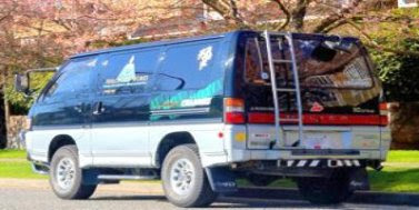
Freestyler
PS: There's more shots from the trip located HERE. Check'em out.
Off we go! Leaving Vancouver

Uh, So were are we going anyways? Better let the girl have the map.

Sweet... after driving up and down 'mainstreet' in D'arcy a few times, we find the Portage road.

Start of the Highline Road. Leaving D'arcy. (the road goes off to the left)

The view looking back at D'arcy. It was a touch steep getting up to this point.

Continuing on-wards and up-wards!

At the first bridge crossing. Stopped for actions shots.

Bridge #1 Action shot!

Well... Look what we found here... The sign says 9tons. Time to scout it out.

Here's looking back. Funny thing is that when I crossed it on foot, I could feel the bridge move oh-so-slightly under my massive 195lbs, which is over top of a older burnt out bridge, which is in turn over top of a 50ft ravine. *thumbsup*

... less thinking, more driving!

Here's a rather nice pile of rocks, near a lookout point.

The view from said lookout! (torwards D'arcy)

The view from camp at the end of day 1

Setting up camp on the end of day 1

Sweet a train! Needs more horn.

Off we go on the start of day 2. Back on the highline.

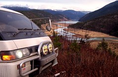
The view from mid drive. The Delica is in full force

The view from mid drive #2

Interesting sign placement...

Now entering downtown Seton Portage.

Here's the Seton Portage visitor's center. An old train car and a welcoming sign

Must be where BC gets it's power. These things are almost big enough to drive the van though

Now it's off to the top of Mission Pass!

Sweet. Lillooet isn't that far. *ignores the sign below*

Looking back at the top of the Mission Pass from the Nosebag FSR

Delica FSR action shot. Nosebag FSR had some pretty epic views.

Not bad. This could be alot worse.

Now heading east from the top of the Mission Pass. This pic looks back towards Seton Portage and D'arcy.

*scratches head* Hmmm... I wonder what happens when the Altimeter goes above 2km and into the orange lines...

On the way back to the Mission Pass peak. Nice little sun shower caught us.

The Mission Pass grade: 14% over 8km. I'll rate this a steep.

Back at the Camp site... looking up from the tracks. End of Day 2

/end


 Good Ship